Pennsylvania Pocket Maps 6.3
Continue to app
Free Version
Publisher Description


Spring 2024: Be prepared for your adventure without Wi-Fi or mobile service! Download Pennsylvania maps for national parks, monuments and state parks before you hike.
Be prepared! Plan your next trip to one of the great Pennsylvania parks. Download maps and guides before you venture into the Wi-Fi free wilderness.
Discover
- 75+ national parks, state parks, monuments, forests
- 150+ neatly folded maps by the National Park Service, Bureau of Land Management, United States Forest Services, and other agencies.
- 100+ campgrounds and campsites
- 1,600+ trails and trailheads
- 72,000+ points of interests
Plan
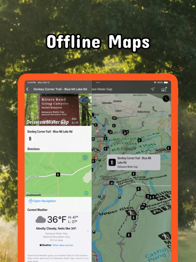
- Download maps, park brochures, and newspapers. These downloads are ready when you are offline and off the grid in the great outdoors.
- Download arbitrary map sections as offline packs.
- Photo galleries, panorama views.
- Share links to parks and maps with friends
Have fun
- GPS and GPX support: record your hikes, import GPX routes, tracks and waypoints for your hiking trails.
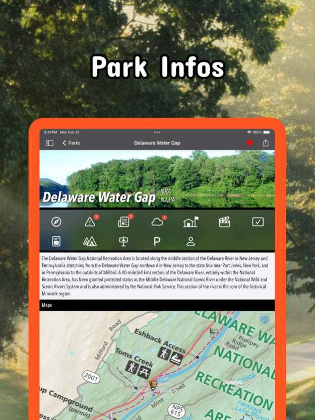
- Detailed national park information: alerts, news, visitor centers, campgrounds, driving directions, weather.
- Open your favorite maps app to get a route to the selected park.
- Current weather conditions, easy access to multi-day forecasts, sunrise and sunset times.
- Push notifications for park alerts, park news, weather warnings
So download maps and guides for:
* Allegheny, Allegheny Islands, Allegheny Portage Railroad, Appalachian, Archbald Pothole
* Bald Eagle, Beltzville, Bendigo, Benjamin Rush, Big Pocono, Big Spring, Black Moshannon, Blue Knob, Boyd Big Tree, Buchanan's Birthplace, Bucktail
* Caledonia, Canoe Creek, Captain John Smith Chesapeake, Champman, Cherry Springs, Cherry Valley, Chesapeake Bay, Chesapeake Bay Gateways and Watertrails Network, Codorus, Colonel Denning, Colton Point, Cook Forest, Cowans Gap
* Delaware & Lehigh, Delaware Canal, Delaware Water Gap, Denton Hill
* Edgar Allen Poe, Eisenhower, Elk, Erie, Erie Bluffs, Evansburg
* First State, Flight 93, Fort Necessity, Fort Washington, Fowlers Hollow, Frances Slocum, French Creek, Friendship Hill
* Gettysburg, Gifford Pinchot, Gloria Dei Church, Gouldsboro, Greenwood Furnace
* Hickory Run, Hopewell Furnace
* Independence
* John Heinz at Tinicum, Johnstown Flood, Journey Through Hallowed Ground
* Kinzua Bridge
* Laurel Hill, Laurel Ridge, Lehigh Gorge, Lower Delaware
* Moraine
* Nockamixon, North Country,
* Ohiopyle, Oil Creek, Oil Region
* Potomac Heritage, Presque Isle, Prince Gallitzin, Pymatuning
* Raccoon Creek, Ricketts Glen, Rivers of Steel
* Shawnee, Steamtown,
* Thaddeus Kosciuszko, Tobyhanna
* Upper Delaware
* Valley Forge
* Washington-Rochambeau Revolutionary Route
- FULL ACCESS is available for a for $3.49/three month (after a free 3-days trial period) or $2.49/two months or $7.49/year. You can subscribe and pay through your iTunes account. The account will be charged for renewal within 24-hours prior to the end of the current period, and identify the cost of the renewal. Your subscription will automatically renew unless canceled at least 24 hours before the end of the current period. Auto-renew can be turned off anytime by going to your Account Settings in iTunes after purchase.
- Continued use of GPS running in the background can dramatically decrease battery life.
LEGAL
Terms of Use: https://www.icoat.de/pocketmaps/terms
Privacy Policy: https://www.icoat.de/pocketmaps/privacy
Apr 12, 2024
Version 6.3
Spring 2024
Updates: Contains the latest data by the National Park Service (NPS), Bureau of Land Management (BLM), United States Forest Service (USFS) and recreation.gov.
About Pennsylvania Pocket Maps
Pennsylvania Pocket Maps is a free app for iOS published in the Recreation list of apps, part of Home & Hobby.
The company that develops Pennsylvania Pocket Maps is Alex Gugel. The latest version released by its developer is 6.3.
To install Pennsylvania Pocket Maps on your iOS device, just click the green Continue To App button above to start the installation process. The app is listed on our website since 2024-04-12 and was downloaded 1 times. We have already checked if the download link is safe, however for your own protection we recommend that you scan the downloaded app with your antivirus. Your antivirus may detect the Pennsylvania Pocket Maps as malware if the download link is broken.
How to install Pennsylvania Pocket Maps on your iOS device:
- Click on the Continue To App button on our website. This will redirect you to the App Store.
- Once the Pennsylvania Pocket Maps is shown in the iTunes listing of your iOS device, you can start its download and installation. Tap on the GET button to the right of the app to start downloading it.
- If you are not logged-in the iOS appstore app, you'll be prompted for your your Apple ID and/or password.
- After Pennsylvania Pocket Maps is downloaded, you'll see an INSTALL button to the right. Tap on it to start the actual installation of the iOS app.
- Once installation is finished you can tap on the OPEN button to start it. Its icon will also be added to your device home screen.
